Tuesday, October 23, 2012

Grand Canyon

What can I write about the Grand Canyon, which pictures should I post when no picture on earth can portray the impression one has when standing at the rim and trying to digest the incredible and dramatic panorama. It is impossible to ban the 180 degree vista in one photo, and it is equally impossible to picture the scenery as it changes with the angle and the color of the sun between sunrise and sunset. Here is my humble try:

The morning sun shining on the western slope of the side valley where the Bright Angel trail switchbacks down to the river 
The same view in the bright midday sun
Grand Canyon at sunset

One of the rare views from the rim on the river, 5,000 ft below


Indian Gardens plateau, 3,300 ft below the rim

I could not resist the temptation to hike the Bright Angel trail down to Indian Gardens, a 9 mi (14 km) round trip over a 3,300 ft (1.000 m) vertical drop. The mean thing is that - unlike "conventional" mountain hiking - the hike starts downhill in the usually cool morning, and uphill after the canyon heats up in the morning sun. The last time I walked down that trail was 17 years ago, and I was really proud that it was not more difficult this time.
View from Indian Gardens Plateau up to the rim
Grand Canyon after sunset


Monday, October 22, 2012

Bryce Canyon

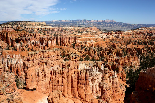
We visited the Bryce Canyon National Park while we stayed at the Kodachrome Basin campground (see last post). We hiked to Queens Gardens and further down the canyon along the Navaho loop. There is not much to say about Bryce Canyon - most people know how erosion, over the course of many million years, created something like a whim of nature that is pretty unique on earth. We enjoyed it immensely, and would encourage anyone who visits America's southwest to spare a day or two for this natural wonder.


Sunday, October 21, 2012

The Grand Staircase

Who knows what the Grand Staircase is or has even heard of it? We definitely didn't, although we travelled the area several times before.
It has even the status of a National Monument (exactly: Grand Staircase Escalante National Monument) and comprises a large area in southern Utah where the erosion weathered down the Colorado Plateau (basically an ancient seabed that was uplifted by colliding tectonic plates some 100 million years ago) from about 9,000 ft (2.700 m) to 3,500 ft (1.050 m). Due to the sedimentary nature of the rock formations, the erosion - mainly caused by run-off waters from the Plateau - resulted in huge steps and not in smooth slopes.
Vermilion Cliffs
 The Vermilion Cliffs (in the background)  mark the last step at the southern end of the Grand Staircase.  The cliff in the front of the picture is the edge of the Colorado canyon, about 10 mi downstream of the Lake Powell dam. Although outside of the National Monument, the Vermilion Cliffs geologically are part of the Grand Staircase.


The Colorado marks the south end of the Grand Staircase

The Grand Staircase has much more to show than just the red sandstone above. Each sediment layer has different colors and erosion resistance, resulting in a wonderful diversity of shapes and colors.


Cottonwood Canyon, accessible only by 4-WD vehicles


Isn't that awesome? Benjamin did not want to believe that these "sculptures" were not man-made!
 
Grosvenor Arch in Cottonwood Canyon


We stayed for three days in a campground in the Kodachrome Basin State Park that is part of the National Monument. Although it just offers dry camping, we unanimously voted our campsite and the whole campgound the most beautiful one of our whole trip.

Kodachrome Basin Campground

View from our campsite


Friday, October 19, 2012

Zion National Park

Coming from Las Vegas, our next stop was Zion National Park, located in southern Utah about 160 miles northeast of Las Vegas. Our travel day and the following day, when we visited Zion, were the first rainy days since we left Hilton Head - no blue skies in our pictures for the first time!
The main - and most spectacular - feature of the park is the 15 mi long Zion Canyon, carved into the so-called red Navaho Sandstone by the Virgin river. The canyon walls rise up to 2000 ft (600 m) above the river and narrow to a width of only 20 ft (6 m) at the end of the part that is accessible by road and/or trail.
We stayed in the Watchman campground inside the National Park where the rubber lining of our trailer roof was damaged by low hanging tree branches - not good in the pouring rain we had this day!

Where the canyon road dead ends, the canyon remains accessible for another mile or so via a trail along the Virgin river. At the end of this trail, the only way to continue into the still narrowing gorge is by wading in the river, something we decided to skip after we checked the water temperature!


Maybe we'll have to come back again in sunshine!


The Virgin cuts away its canyon faster than its tributaries can cut away their own streambeds, so tributaries end in waterfalls from hanging valleys where they meet the Virgin. Therefore, dozens of waterfalls decorate the canyon walls, some of them 1000 ft or more high.
 
When we left Zion the next day, the rain system had moved away, but not without leaving a snow blanket at altitudes above 6,000 ft (1.800 m). We drove eastward on state route 14 that traverses the Dixie National Forest above 8,000 ft (2.400 m) - presenting us a phantastistic winter-wonderland that more than compensated us for the two days of rain.
 
View eastwards toward the 8,000 ft high Colorado Plateau as it stair-steps down in the Bryce Canyon area
 
 
Did I already mention that the yellow and golden colors of the Aspen is one of my most favorite views?


Thursday, October 18, 2012

Eastern Sierra Nevada and Death Valley

From Lassen Volcanic National Park, we took the scenic US 89 south to Lake Tahoe - where we stayed for two nights,  and from there along the eastern side of the Sierra Nevada on US 395 down to Mono Lake and Bishop, where we spent another two nights.
Lake Tahoe as seen from Incline Village at the north side of the lake

US 395 is a quite interesting road, as it follows the eastern foothills of the Sierra Nevada: While the scenery to the right (west) is lush and green, it is arid and desert-like on the other side, even around lakes like the Mono Lake.
Mono Lake

Not far away from Mono Lake, we found another one of these wonderful National Forest campgrounds, this time at the north side of the June Lake.

OH Ridge campground at the June Lake


June Lake


Here, at the east side of the Sierra Nevada, is the home of the oldest living beings on earth: The Bristlecone Pine. Yes, the oldest trees are not the giant Sequoias or Redwoods that are growing on the western slopes of the Sierra Nevada, or elsewhere along the Pacific coast - like we thought - but the gnarled and rather unimpressive Bristlecone Pines that grow east of Bishop, CA, at an altitude of almost 10,000 ft. At this altitude, the growing season is only 1-2 months a year, and the annual rings are so close together that they can only be identified (and counted!) using a microscope. The oldest one of these trees is over 4,800 years old - the oldest living thing on earth.


These trees were already 2,000 years old when Julius Caesar ruled the Roman Empire!
 
Our next destination was Las Vegas, where we were to meet Silke's parents who arrived from Germany to join our trip for two weeks. Coming from Bishop, we had to choose wether to take CA 168 eastwards or CA 190 across the Death Valley. After checking out the 168, we found that the road was too narrow and full of sharp turns so that it would have been too time consuming with our 36 ft. trailer. So we took the Death Valley road, but we decided not to stop there because the temperature was still above 100 F (37 C). Quite a change of scenery after many weeks of mountains and forests and lush vegetation!

Approaching Death Valley


The lowest point in Death Valley is 282 ft (86 m) below sea level, and is the location of the highest ever recorded temperature on earth: 136 F (58 C), measured in 1913.

Death Valley near Furnace Creek, temperature 102 F in October 2012


Wednesday, October 17, 2012

The Volcanic Legacy - Crater Lake and Lassen Volcanic

Our last stops on our tour of the volcanic features of the Cascades were Crater Lake and Lassen Volcanic National Parks.
After the last eruption of Mt. Mazama, about 7,700 years ago, the empty magma chamber collapsed, leaving behind a 2,200 ft deep caldera which was filled with rain water over the following several hundred years. Since the lake has no drain, its level is determined by the balance of precipitation and evaporation which currently results in a maximum depth of 1,950 ft., making it the deepest lake in the US.
Due to the absence of inflows, the water is extremely clear - the underwater visibility is about 100 ft. An even more spectacular consequence is the incredibly deep blue color of the lake - impossible to fully demonstrate in a photo, but here are a few attempts:
Crater Lake - the colors are not edited!


We stayed at a National Forest campground located at Lake Diamond, 1/2 hour north of Crater Lake. Wunderful nature, lots of privacy between the campsites, perfect for letting go and unwinding. The tradeoff - no hookups, no cell phone, no internet - is a no-brainer!
Our campsite at Lake Diamond

After an easy-to-forget two-night stop at a KOA campground in Klamath Falls, Oregon, we stopped at a very remarkable private RV park north of Lassen Volcanic National Park. The campground was located right in the middle of a ranch, where we were surrounded by countless cattle:

Nice, shady campsites with lots of space
The funny thing was that the cows were mooing incessantly when we arrived, not just a few, but dozens of them at the same time. Being the self-appointed cow specialist, I predicted that the mooing would stop by nightfall since "cows sleep at night and don't moo". My fall from grace could not be harder, because those cows would barely notice the night and the mooing concert went on throughout the whole night without any change.
All 4 sides of the campground looked like that
The next day, while on a hike in Lassen Volcanic NP, we happened to meet the owner of a ranch in Oregon, and he explained that we had happened to arrive the day when the calves had been separated from their mothers, which happens at every cattle ranch once each fall. And because they, understandably, don't enjoy being separated, moms and calves moo like crazy for two days, and then they forget their grief and stop mooing. Interesting lesson learned!

Lassen Volcanic NP is a worthwile stop not only because of a beautiful scenery, but also because it features the largest hydrothermal activities  in North America outside Yellowstone.

This valley with lots of fumaroles, hot pots, steam vents etc. is located at the end of a 30-min trail and is named "Bumpass Hell". No idea why!


Friday, October 5, 2012

The Volcanic Legacy - Central Oregon

From British Columbia to California, a chain of vulcanoes are evidence of the tectonic activities that unfold many miles under the surface in North America's far west. A large number of eruptions shaped and formed the landscape around the vulcanoes, sometimes leaving behind eerie, barren lava and ash fields like in central Oregon, but also creating places of almost unreal beauty, like Crater Lake.
We stayed several days at an RV park in Bend, Oregon, a nice medium-sized town with a pittoresque downtown shopping area, and explored scenic central Oregon from here.
Downtown Bend, OR

About one hour away, huge lava fields bear witness to several large eruptions 1500 - 2000 years ago. It is fascinating that even after such a long time still only very little vegetation is able to gain a foothold on this ground.


Two lava streams have merged here - still clear to see


One large eruption - about 7,000 years ago - created this huge lava field:

An ash and pumice field from another eruption, about 1,700 years ago. This is the area where the astronauts did part of the training for the Apollo moon landing missions in the 1960's and 70's 

Another interesting feature of the area are the lava tubes that formed during eruptions. This one is over 8,000 years old and remained unchanged during all the time. It is several miles long and up to 300 feet below the surface. About 1 mile is accessible to visitors - some parts of the tube are over 60 ft high and 30 ft wide. The tube is not illuminated, but pitch black - except for the flashlight that scares unsuspecting visitors!