Thursday, October 18, 2012

Eastern Sierra Nevada and Death Valley

From Lassen Volcanic National Park, we took the scenic US 89 south to Lake Tahoe - where we stayed for two nights,  and from there along the eastern side of the Sierra Nevada on US 395 down to Mono Lake and Bishop, where we spent another two nights.
Lake Tahoe as seen from Incline Village at the north side of the lake

US 395 is a quite interesting road, as it follows the eastern foothills of the Sierra Nevada: While the scenery to the right (west) is lush and green, it is arid and desert-like on the other side, even around lakes like the Mono Lake.
Mono Lake

Not far away from Mono Lake, we found another one of these wonderful National Forest campgrounds, this time at the north side of the June Lake.

OH Ridge campground at the June Lake


June Lake


Here, at the east side of the Sierra Nevada, is the home of the oldest living beings on earth: The Bristlecone Pine. Yes, the oldest trees are not the giant Sequoias or Redwoods that are growing on the western slopes of the Sierra Nevada, or elsewhere along the Pacific coast - like we thought - but the gnarled and rather unimpressive Bristlecone Pines that grow east of Bishop, CA, at an altitude of almost 10,000 ft. At this altitude, the growing season is only 1-2 months a year, and the annual rings are so close together that they can only be identified (and counted!) using a microscope. The oldest one of these trees is over 4,800 years old - the oldest living thing on earth.


These trees were already 2,000 years old when Julius Caesar ruled the Roman Empire!
 
Our next destination was Las Vegas, where we were to meet Silke's parents who arrived from Germany to join our trip for two weeks. Coming from Bishop, we had to choose wether to take CA 168 eastwards or CA 190 across the Death Valley. After checking out the 168, we found that the road was too narrow and full of sharp turns so that it would have been too time consuming with our 36 ft. trailer. So we took the Death Valley road, but we decided not to stop there because the temperature was still above 100 F (37 C). Quite a change of scenery after many weeks of mountains and forests and lush vegetation!

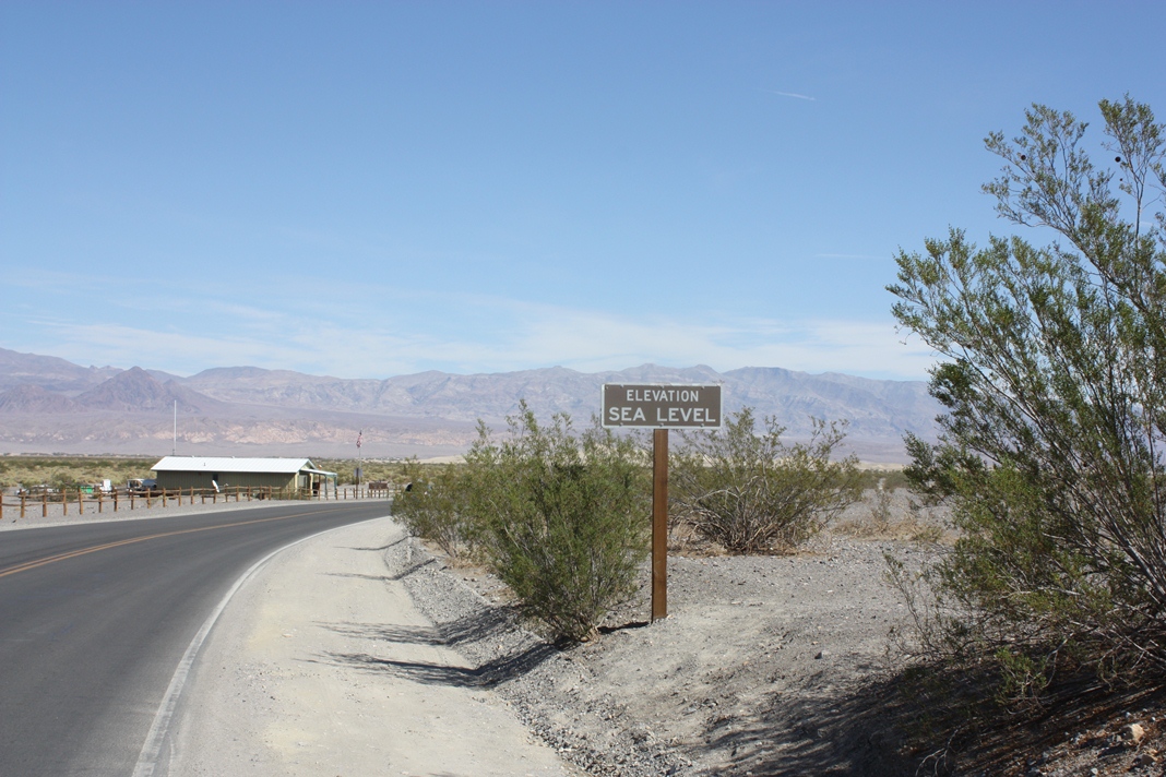
Approaching Death Valley


The lowest point in Death Valley is 282 ft (86 m) below sea level, and is the location of the highest ever recorded temperature on earth: 136 F (58 C), measured in 1913.

Death Valley near Furnace Creek, temperature 102 F in October 2012


Wednesday, October 17, 2012

The Volcanic Legacy - Crater Lake and Lassen Volcanic

Our last stops on our tour of the volcanic features of the Cascades were Crater Lake and Lassen Volcanic National Parks.
After the last eruption of Mt. Mazama, about 7,700 years ago, the empty magma chamber collapsed, leaving behind a 2,200 ft deep caldera which was filled with rain water over the following several hundred years. Since the lake has no drain, its level is determined by the balance of precipitation and evaporation which currently results in a maximum depth of 1,950 ft., making it the deepest lake in the US.
Due to the absence of inflows, the water is extremely clear - the underwater visibility is about 100 ft. An even more spectacular consequence is the incredibly deep blue color of the lake - impossible to fully demonstrate in a photo, but here are a few attempts:
Crater Lake - the colors are not edited!


We stayed at a National Forest campground located at Lake Diamond, 1/2 hour north of Crater Lake. Wunderful nature, lots of privacy between the campsites, perfect for letting go and unwinding. The tradeoff - no hookups, no cell phone, no internet - is a no-brainer!
Our campsite at Lake Diamond

After an easy-to-forget two-night stop at a KOA campground in Klamath Falls, Oregon, we stopped at a very remarkable private RV park north of Lassen Volcanic National Park. The campground was located right in the middle of a ranch, where we were surrounded by countless cattle:

Nice, shady campsites with lots of space
The funny thing was that the cows were mooing incessantly when we arrived, not just a few, but dozens of them at the same time. Being the self-appointed cow specialist, I predicted that the mooing would stop by nightfall since "cows sleep at night and don't moo". My fall from grace could not be harder, because those cows would barely notice the night and the mooing concert went on throughout the whole night without any change.
All 4 sides of the campground looked like that
The next day, while on a hike in Lassen Volcanic NP, we happened to meet the owner of a ranch in Oregon, and he explained that we had happened to arrive the day when the calves had been separated from their mothers, which happens at every cattle ranch once each fall. And because they, understandably, don't enjoy being separated, moms and calves moo like crazy for two days, and then they forget their grief and stop mooing. Interesting lesson learned!

Lassen Volcanic NP is a worthwile stop not only because of a beautiful scenery, but also because it features the largest hydrothermal activities  in North America outside Yellowstone.

This valley with lots of fumaroles, hot pots, steam vents etc. is located at the end of a 30-min trail and is named "Bumpass Hell". No idea why!


Friday, October 5, 2012

The Volcanic Legacy - Central Oregon

From British Columbia to California, a chain of vulcanoes are evidence of the tectonic activities that unfold many miles under the surface in North America's far west. A large number of eruptions shaped and formed the landscape around the vulcanoes, sometimes leaving behind eerie, barren lava and ash fields like in central Oregon, but also creating places of almost unreal beauty, like Crater Lake.
We stayed several days at an RV park in Bend, Oregon, a nice medium-sized town with a pittoresque downtown shopping area, and explored scenic central Oregon from here.
Downtown Bend, OR

About one hour away, huge lava fields bear witness to several large eruptions 1500 - 2000 years ago. It is fascinating that even after such a long time still only very little vegetation is able to gain a foothold on this ground.


Two lava streams have merged here - still clear to see


One large eruption - about 7,000 years ago - created this huge lava field:

An ash and pumice field from another eruption, about 1,700 years ago. This is the area where the astronauts did part of the training for the Apollo moon landing missions in the 1960's and 70's 

Another interesting feature of the area are the lava tubes that formed during eruptions. This one is over 8,000 years old and remained unchanged during all the time. It is several miles long and up to 300 feet below the surface. About 1 mile is accessible to visitors - some parts of the tube are over 60 ft high and 30 ft wide. The tube is not illuminated, but pitch black - except for the flashlight that scares unsuspecting visitors!


Monday, October 1, 2012

The emotional side after two month of travel


Today is Monday, October 1st and we are on the road for two full month! Wow! It actually feels like a lot longer… The life where we had a large house, lots of space, a dishwasher, washer and dryer, heated bathroom floors, many, many rooms and own space for privacy seems to be ages ago!
I do miss my Hilton Head friends, the socializing, the hanging out, the lunches, the good conversations! I realized that I do not miss the heat or humidity though J. We are in Central Oregon right now,: the towns of Bend and Klamath Falls and Crater Lake. Every day the sun shines, the air is very dry and nighttime temperatures are in the low 40s. That is quite nice but Ben and I do have very dry skin and lips (which is bothersome).
By the way, since we started the trip 8 weeks ago we have not had one full day of rain! It rained approx. 3 nights and two half days! That’s it!!! Isn’t that amazing?
Even on the Olympic Peninsula, where it supposedly always rains, we had nothing but sunshine! Most days we eat outside at our picnic table…which makes life in our RV so much easier! If the weather is nice and the campground in beautiful nature then life cannot get better! Unfortunately we do not always find RV parks in beautiful nature; especially when we plan to visit cities.
Right now it seems week 4 and 5 were the toughest ones (so far), after quite some fighting, miscommunications, frustrations and some tears and then finally some good, creative communications we are on a better path. We try to stay longer in one place, try to give the other ones more space and team up in pairs so the 3rd person is off for some time alone. That seems to work much better! Each one of us misses different things and we also need different things to be happy, so compromising is a huge effort in our family J. But it seems we all settled in our own way into the new way of life. While I think life cannot go on like this forever, Benjy and Manfred want to go on and on and on and on. Interestingly they are not bothered by the extremely tight space. We will see how this ends?!
Tommy interrupting my work!
Tommy found a place in our family! He settled right in, like Manfred had predicted. That is a huge relief for Benjy. He finally has a friend, someone to play with! And Tommy does like to play….he is young, energetic and demanding and keeps Benjy (and me) quite busy! 
Too big for the scratching post :-)


Helping with home work!
Now we travel with a cat! By the way, Tommy does not really like to drive. I guess he did so well the first week because he was still all mixed up from having been neutered. He obviously needed more rest and sleep and did not mind the driving. However, after he became his old curious, energetic self he did not care for driving in a car anymore…we tried 100 different ways but he would not settle down. Finally we left him locked into the bedroom in our trailer (I traveled with him, laying on the bed, reading a book) and sure enough: that was his home, he knew the room and settled right into looking out the window and even falling asleep for a bit! He is still alert and easily frightened but he does not really seem to mind. Whenever we arrive at an RV Park, he loves to be back in the living room, playing with his toys, hanging on his favorite places and going for walks on his leash. 
Yes, he even accepts being leashed! Naturally he would love to run free and I am pretty sure he would not run away…..but we are afraid he might get lost. Too many different campgrounds in such a short amount of time!
We stayed one week in Bend, OR and in that RV Park we met 5 other campers with cats! On the leash, walking their cats…..so we had talks between “cat people”. Benjy absolutely loved it! First thing in the morning he walked Tommy over to meet “Kitty” and “Ranger”, two tomcats living/vacationing in our “street”.  I am still amazed about the surprising turn our RV life took! Even Manfred walks Tommy on the leash!!!
Like always, the nature we see is mind-boggling!!! Crater Lake is majestic! I absolutely loved it! The campground we stayed in was in a National Forest at a lake…so, so beautiful! Hard to describe! It is not hard to feel close to God in this kind of environment.
So on the one hand we have the incredible beautiful nature, the perfect weather and many times great RV Parks and on the other hand all the things that do not work: like internet, that seems to be an ongoing challenge! Even having our own internet with Verizon and our own network with …those machines, they never seem to work. Something breaks, we have to send it in and having it send back is the big, big problem!!! So many times we went to the post office or an UPS office in some town to pick something ordered and expected up and it is NOT there! Frustration!!! RV water pump broke, hitch plate comes loose every time after driving, air mattress of Ben’s bed deformed and shows weird, uncomfortable bumps, one of our three gas burners on the stove broke….there is always something! After 2 months we learned that this is the name of the game! We are NOT on vacation! This is real life! Like when you own a home, there is always something…owning and living on an RV is not much different. Except that you can move your home to wherever you want to J!

Ben exploring a pumice desert

Ben after a grey jay (camp robber) stole half of his lunch!

grey jay or camp robber
 In conclusion I can say we do better than 2-3 weeks ago! Probably because so many dear friends are praying for us…! Keep doing so, please !
In 9 days my parents will arrive from Germany! We are going to pick them up in Las Vegas and then we travel together for 2 weeks! But they will sleep in motels or cabins. That will be another challenging experience!

At the Columbia River

The Columbia is the largest river in America's Pacific Northwest. For about 100 mi east of Portland, Oregon, the Columbia works its way through the Cascade Range and formed the Columbia River Gorge, up to 4,000 ft (1.200 m) deep and well known because of its dramatic scenic views. It also marks the state line between Washington and Oregon.
We stayed there for 5 days in two different campgrounds near the towns of Cascade Locks and Hood River, respectively.
The Columbia near Portland, OR

Located near Cascade Locks is the Bonneville Dam, the last one of 14 dams along the river which provide electricity and irrigation and prevent flooding. The river's heavy flow and its relatively steep gradient gives it tremendous potential for the generation of electricity. The 14 dams have an installed capacity of over 25,000 MW, and the three major tributary rivers another 10,000 MW.

Bonneville dam


The fish ladder - through underwater windows we could actually see the salmon winding their way up the ladder


Although the Bonneville dam does not exactly look impressive, its electric capacity of 1,218 MW is about the same as the huge Glen Canyon dam of the Colorado:
Glen Canyon dam of the Colorado in Arizona

The reason is that the water flow of the Columbia is so much greater than of the Colorado. By the way, both power plants ar dwarfed by the Grand Coulee dam of the Columbia, with 6,800 MW the largest hydroelectric plant in the US and one of the largest in the world.


The Columbia River Gorge between Portland and Cascade Locks - hazy because of wildfires


The historic river highway winding through the canyon east of Hood River


Around Hood River, OR, where the canyon walls are the steepest, the gorge creates a draft that results in almost continuously blowing high winds, which in turn attract thousands of windsurfers. Consequently, Hood River is dubbed as "World Capital of Surfing".


Near Hood River


Wednesday, September 26, 2012

Mt. St. Helens

Coming from the Olympic peninsula, we stayed a couple nights at a rustic campground in the Seaquest state park. About an hour away is Mt. St. Helens, the vulcano that erupted spectacularly in May 1980. In spite of many warning signs as early as March of the same year, the unexpected lateral blast of the eruption took the lives of 57 people and devastated  a large area around the vulcano. Triggered by a massive landslide, the eruption blasted away the entire top and the northwestern side of the mountain, taking away over 1,300 ft of the original height.
Mt. St. Helens erupted sideways, blasting a huge gap into the mountain slope. The haze in this and the following photos is caused by wildfires in eastern Washington and Oregon

Prior to the eruption, Mt. St. Helens looked like all the other vulcanoes of the Cascade range, like for instance this one:

Mt. Hood in northwest Oregon


Even 32 years after the eruption, the devastating results of the blast are plain to see.

Distance: 5 mi. The lake and the forest that have been here before the eruption, were buried under lava, and vegetatiuon did not recover yet.

Distance: 8 mi. Forests were flattened, and nothing survived


Distance: 15 mi.


Thursday, September 20, 2012

Olympic Peninsula

Back in the US, our first major destination was the Olympic Peninsula in the northwest corner of Washington state, with the Olympic National Park and the only temperate climate rainforest in America.
But before getting there, we had to overcome a big obstacle: Entering the US of A! After waiting 45 minutes in line to get to the immigration officer's booth, he told us our RV needs an inspection for conformity with US agricultural rules. So we parked the RV and waited 20 minutes for the inspectors to finish their investigation, the result of which was that we had to dump the fruit and veggies that we had forgotten about. When we thought we were allowed to resume our trip, the inspector said that we also couldn't take the firewood that we always have in our truck bed, because it didn't have a certificate for the special heat treatment that is required for importing firewood. "Ok", I said, "then we must  leave it here". However, she made it clear, friendly but firmly, that we have to bring it back to Canadian soil - first through Canadian immigration, and then back another 40 minutes in line for US immigration. My "you must be kidding" didn't help much. Can anyone imagine how much I fumed? My question if burning it up right there on the parking lot would be a sufficient heat treatment almost got me in contact with the next law enforcement official. So, we turned around into Canada, made a U-turn a couple of miles later, threw all the firewood in the grass (which I determined was no pollution because it didn't have the heat treatment) and lined up again - the whole process took us over 2 hours!
A nice new experience during the rest of this day trip was a ferry ride that we had to take to get from Whidbey Island to the Olympic Peninsula.
Our campground 20 minutes west of Port Angeles was located inside a county recreation area right at the sea border, with spectacular views onto the Pacific, specifically on the Juan de Fuca Strait that separates the Peninsula from Victoria Island, Canada.


At the Juan de Fuca Strait, with Vancouver Island in the distance

With over 930,000 acres (3.734 qkm), Olympic NP is one of the largest national parks in USA. The main features are a large glacial mountain range in the center, up to almost 10,000 ft, the temperate rain forest mentioned above, mainly at the western slopes of the mountains, and the Pacific coastline. The rain forest gets about 150 inches (380 cm) rain annually and is the wettest area in the continental US.


The center of the NP, photo taken from Hurricane Ridge
 
 
In the Hoh rain forest, near the town of Forks at the west side of the park
 
 
Benjamin at one of the giant spruces that strive in the rain forest
 
Driftwood at the Pacific west coast, close to La Push (well known to all "Twilight" fans!)
 
What a man...